Introduction | Towns & Villages | Mountains | Landscapes | Buildings | Hiking | Plants & Animals | Photos
Towns and Villages: Near Mont Chanis
About the Villages | Additional Information | Map | Photo Album | Hiking Tours | Links
This page introduces a couple of villages to the south and east of Mont Chanis: Marcilhac, Rocherolles, Mont Chanis, and La Chapuze.
About the Villages
Marcilhac
Marcilhac (930 m) is our "point of entry" into this area, because here was the "camping a la ferme" located, where we stayed overnight in 1990. And, after a certain break, we visited this place every year until 2014, sometimes even twice a year. The campsite (about 900 m) was a "remnant" of a farm, which was abandoned by its owners and later sold as a residential building. The owners built a new house nearby and kept a few meadows, which they leased or used for the camping site.
Marcilhac is the village closest to the D28, which you could hear well from the campsite, and is situated on the road to Rocherolles, with a turnoff to the north. Farmers are no longer active in the village, but there are a couple of "half-time" farmers having tractors and cattle. In addition, there are many cats and especially annoying dogs in the village... The village still has a "beate" (or assemblée) and a public oven. At least several years ago, the oven was "activated" for the village festival in July, in which we took part twice. Going north on the village road, you reach the forest around Mont Chanis, following the road to Rochrolles, you have a beautiful view of the Suc de Monac and in the direction of Saint-Julien-Chapteuil.
Rocherolles
If you continue along the road from Marcilhac to Rocherolles (985 m), you will pass a large farm, so there is still a farmer active in this village. The village runs along a road that branches out at the end: On the one hand, it continues uphill to Mont Chanis and on the other hand downhill to La Chapuze, which is quite close to Saint-Julien-Chapteuil. Rocherolles also has an assemblée/beate on this branch of the road.
Mont Chanis
The village Mont Chanis (1,031 m) is located close to the mountain of the same name, and there are also some climbing walls located in old quarries. Otherwise, the world ends here, and we turn south in this village, on a path that offers beautiful views in the direction of Saint Julien-Chapteuil and back to Mont Chanis.
La Chapuze
If you go further south, you can get to La Chapuze (892 m) - or you can turn west to Rocherolles and return to Marcilhac (which we used to do, because there was our camping site). La Chapuze is already a little larger and you can feel the closeness to Saint-Julien-Chapteuil. The village also has an assemblée/beate, and in the direction of the Combe Noir valley and mills you can find the former house (or birthplace) of Jules Romain. From La Chapuze you can continue by car to Saint Julien-Chapteuil, on foot you can also walk along the valley of the small river Merlan, which you also cross in Marcilhac (and which was at the border of the farm of our campsite owners - they catched crayfish there at that time). We usually continue our way to Le Collet and Mon(n)ac to finally get to our new campsite in Sumène (earlier, we fought our way up to the campsite in Marcilhac...).
Mountains
The mountains for these villages are of course the Mont Chanis (1,231 m, several summits), whose summit is difficult to find and climb, as well as our former "neighbor mountain," the Suc de Monac (1,022 m), which we climbed once but otherwise only circumnavigated.
Additional Information
Curiosities
- The assemblées/beates in Marcilhac, Rocherolles, and Mont Chanis
- Views of the Suc de Monac and in the direction of Saint-Julien-Chapteuil, views of Mont Chanis and its rocks (previous quarries).
Well-Known Persons
- Jules Romain (1885–1972), writer (Knock ou le Triomphe de la médecine, Les Copaines, Les Hommes de bonne volonté)
Facilities
- Overnight accommodation in yurts near La Chapuze
Specialties
- Climbing facilities at Mont Chanis
Towns and Villages Near-by
- Saint-Julien-Chapteuil
- Mon(n)ac, Le Collet
- Bard, La Faye, Villaret, Monedeyres
Road Connections
- D28 north to Le Pertuis zur N91, south to Saint-Julien-Chapteil
- Round trip starting from D28 via Marcilhac, Rocherolles, La Chapuze, to Saint Julien-Chapteuil
Curiosities in the Environment
- Meygal massif
Map
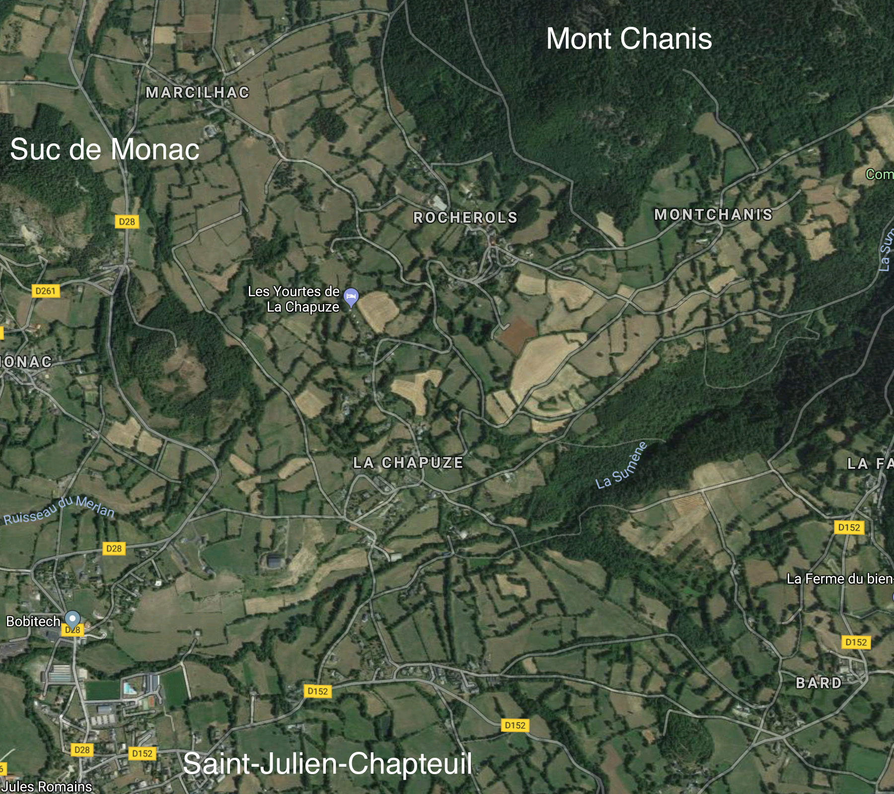
Photo Album
In preparation
Hiking Tours
| Starting Point | Length | Duration | Altitude |
|||||
| Number | Recommended | Alternative | Name | (km) | h:min | min | max | References |
| PR191 | St. Pierre-Eynac | Marcilhac | Circuit de Monac | 9,5 |
2:30 |
775 |
1020 |
23 – Autor de St. Hostien, sur le contreforts du Meygal (It. Péd. En Ht. Loire) |
| PR191 | St. Pierre-Eynac | Marcilhac | Autour de Monac | 8,5 |
2:30 |
768 |
1020 |
Le Pays des Sucs et du Meygal … à pied (15) |
| Magenta: Older version (Randonées pédestre et VTT au pays des sucs - Yssingeaux) | ||||||||
| Blue (italic number): Older version (Itineraires Pedestres en Haute-Loire) | ||||||||
| Red: New | ||||||||
Details:
- Respirando - Les sentiers de Promenades et Randonnées (PR) Respirando: www.respirando.fr/index.php/apied/les-sentiers-de-petites-randonnees-pr-respirando.html
Links
- Saint Julien Chapteuil (site de la commune, F): www.saintjulienchapteuil.fr
- Jules Romains (Wikipedia, DE): de.wikipedia.org/wiki/
- Bienvenue au Pays du Meygal (F): www.auvergne-paysdumeygal.com
- Suc de Monac - 43260 St Pierre Eynac (YouTube): www.youtube.com/watch?v=yMDjwUU1l-o
|
made by |
||
| 12.03.2019 |