Introduction | Towns & Villages | Mountains | Landscapes | Buildings | Hiking | Plants & Animals | Photos
Towns and Villages: Around Queyrières
About the Villages | Additional Information | Map | Photo Album | Hiking Tours | Links
This page introduces a couple of villages around Queyrières: Queyrières, Sénéol, Le Bouchit, La Chaude, Monedeyres and Raffy.
About the Villages
When discussing the villages around Queyrières, I am guided by the trails we follow there (PR192 and PR199).
Queyrières
Queyrières (1177 m, 326 inhabitants) is the main and church town of this area, although the village itself is rather small, nestled around (with various foothills...) a rock with basalt organs. However, the church and the basalt rock can be seen from the south and thus form a "landmark". There's a small Mairie next to the church.
Queyrières is the starting point for several hikes, some of which start at the other end of the hikes (e. g. from the Meygal massif). One such hike, the PR192, leads to the village of Sénéol and circles the Deux Mezères (1187 m and 1200 m; on the map, only the bigger mountain is called "Le Mezère"), two Sucs, of which the larger one features a huge boulder field, from which one has a splendid view in south and west direction. There is also a "sentier biologique," starting in Le Fournial, which leads around the two Mezères, with a short cut across the scree field. It wasn't until 2017 that we really celebrated and appreciated this trail.
In Querières there are several gîtes, further north in the forest there is a restaurant (formerly there was one near the crossroads D152/D18), a primary school, and a large picnic area on the D152 near the crossroads of D152 and D18.
Sénéol
The PR 192 runs from Queyrières to the village of Sénéol (approx. 1100 m) and around the two Mezères (1187 m and 1200 m). From Sénéol you have a beautiful view back to Queyrières. Then one disappears into the forest around the two Mezères, which stretches far to the north. Here you will find the rear end of the aforementioned "sentier biologique," which starts in Le Fournial near the D18.
Le Bouchit
The village of Le Bouchit (about 1050 m) is located on the D18 and the road is quite narrow there... On the town sign there is a "D" added: Boudchit. What does that mean?
La Chaude
Another and longer trail, the PR 199, leads from Queyrières down into the valley towards Mont Chanis (1233, several peaks) and into the village of La Chaude (1071 m, the main part is lower), which is still a real farming village, with all that belongs to it. Until recently, there was a goat farm selling wonderful goat's cheese, both at the farm and at the Monday market in Saint-Julien-Chapteuil. Unfortunately, the female owner has stopped making cheese, and we now have to buy and eat the goat cheese from Gerantes (at Araules)... There are several other farm houses that carry names in that area...
Monedeyres
The PR 199 runs from La Chaude to and through Monedeyres (1011 m), past Mont Chabrier (1230 m), and up to a parking at the forking of two forest roads that run in parallel across the Meygal massif (the one forest road is now closed to public traffic). I describe Monedeyes in another place, and that's why I don't write anything else about this village here. To the northeast of Mont Chabrier, one climbs up a long boulder field (called Shiraz) and finally gets to the above-mentioned parking at the forking of the forest road. Typically, we start our hike to Queyrières, which goes via Raffy, at this parking lot and return along the same path. Thus, we do not pass through Monedeyres and La Chaude. So we mostly just follow the upper part of PR199.
Raffy
From the parking at the forest road, you pass through the forest, cross the D18 and get to Raffy (1267 m on the D18, higher up in the upper part of the village), the place with the best view over the Meygal massif and the plain around Saint-Julien-Chapteuil. In Raffy, there is a place on the D18 where we stopped our car again and again, because you have a beautiful view over the Meygal massif and its foreland in the west. The footpath PR199 runs higher up, the view may be better, but mostly some power lines disturb our photos... Continuing on the PR199, we have beautiful views of Querières with its church and basalt rock, as well as in the direction of Mont Chanis (1233 m, several peaks), Mont Rouge (1159 m), Peyre de Bard (1200 m). and other mountains of the Meygal massif in the background.
By the way, this trail leads along the foot of Montivernoux (1371 m), but so far we haven't really explored this mountain and the large forest area around it...
Mountains
Testavoire (1436 m), Mont Chabrier (1230 m), Mont Chanis (1233 m, several peaks), Mont Rouge (1159 m), Peyre de Bard (1200 m), Montivernoux (1371 m), Deux Mezeres (1187/1202 m)
Additional Information
Curiosities
- Basalt organs in Queyrières
- "Unconsecrated church" in Monedeyres
- Shiraz (rock field) on the slope of the Testavoire (Meygal massif)
- Scree field at the larger Mezère with beautiful view
- Sentier biologique around the Mezères from Le Fournial
- Views from Raffy and on the way from Raffy to Queyrières to the south and west
Facilities
- Gîtes in Queyrières
- Picnic area in Queyrières
Specialties
- Very rural area...
- Cross-country skiing in the Meygal massif in winter
Towns and Villages Near-by
- Saint-Julien-Chapteuil
- Saint Pierre Eynac
- Saint-Hostien
Road Connections
- D152 north from Saint-Julien-Chapteuil to Queyrieres and further on to Yssingeaux
- In Queyrieres, it crosses the D18 from Saint-Hostien to Araules, which allows access to the Meygal massif.
- At Sénéol a small road branches off the D152, passes through Sénéol and then Les Drayes and meets the D18 in La Chaude.
Curiosities in the Environment
- Saint-Julien-Chapteuil with its Romanesque church and other curiosities
- Saint-Pierre-Eynac with its Romanesque church
- Saint-Hostien with its old church
Map
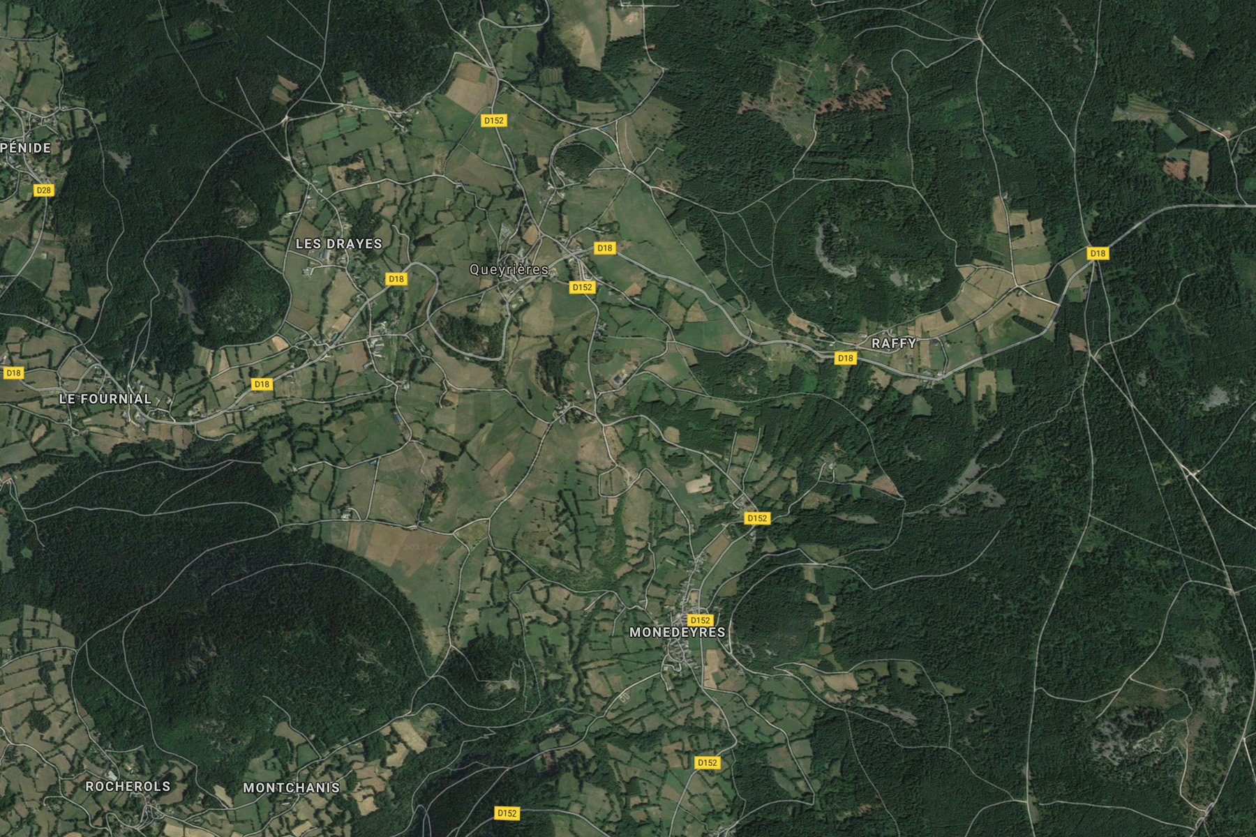
Photo Album
In preparation
Hiking Tours
| Starting Point | Length | Duration | Altitude |
|||||
| Number | Recommended | Alternative | Name | (km) | h:min | min | max | References |
| PR188 | Queyrières | ? | Circuit de la Peyre de Bard | 6 |
1:30 | 970 | 1095 | 23 – Autor de St. Hostien, sur le contreforts du Meygal (It. Péd. En Ht. Loire) |
| PR189 | Queyrières | ? | Circuit du Grand-Testavoyre | 17 |
4:30 | 1040 | 1436 | 19 – En massif du Meygal (It. Péd. En Ht. Loire) |
| PR189 | Queyrières | ? | Le tour du Meygal | 13 |
4:30 | 1040 | 1436 | Le Pays des Sucs et du Meygal … à pied (23) |
| PR192 | Queyrières | Circuit de Sénéol | 6.5 |
1:40 | 1000 | 1175 | 23 – Autor de St. Hostien, sur le contreforts du Meygal (It. Péd. En Ht. Loire) | |
| PR192 | Queyrières | Sénéol et le deux Mézères | 6.5 |
2:00 | 1000 | 1175 | Le Pays des Sucs et du Meygal … à pied (22) | |
| PR199 | Queyrières | Circuit de Monedeyres | 10.5 |
2:50 | 980 | 1280 | 19 – En massif du Meygal (It. Péd. En Ht. Loire) | |
| PR199 | Queyrières | Monedeyres | 9 |
2:50 | 1040 | 1280 | Le Pays des Sucs et du Meygal … à pied (21) | |
| Magenta: Older version (Randonées pédestre et VTT au pays des sucs - Yssingeaux) | ||||||||
| Blue (italic number): Older version (Itineraires Pedestres en Haute-Loire) | ||||||||
| Red: New | ||||||||
Details:
- Respirando - Les sentiers de Promenades et Randonnées (PR) Respirando: www.respirando.fr/index.php/apied/les-sentiers-de-petites-randonnees-pr-respirando.html
Links
- Saint Julien Chapteuil (site de la commune, F): www.saintjulienchapteuil.fr
- Bienvenue au Pays du Meygal (F): www.auvergne-paysdumeygal.com
|
made by |
||
| 12.03.2019 |